Housing Projects

housing image tileAn action of Noosa Housing Strategy 2022  is to investigate opportunities to use available Council-owned land for social housing, affordable housing or crisis accommodation.

Council-owned land at 62 Lake Macdonald Drive, Cooroy (Lot 105 SP118458) is specifically identified as a possible site for housing. More information on this project is available via the project link below. 

For further information, or to assist with affordable housing solutions, please email housing@noosa.qld.gov.au

62 Lake Macdonald Drive, Cooroy, for social and affordable housing

Action 5.5.11 of Noosa Housing Strategy identified 62 Lake MacDonald Drive, Cooroy, to be investigated for social and affordable housing and to undertake appropriate consultation with the local community.  This was in response to the growing need for affordable housing for Noosa residents which is affecting many people and businesses in the region.

62 Lake macdonald drive

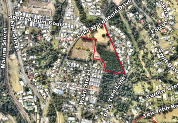
An extensive range of background studies and site investigations have now been conducted and determined the site suitable for housing, and cemetery expansion, subject to the site’s remediation. 

The site is generally free from natural hazard constraints such as flooding and bushfire hazards, a rarity in Noosa Shire where much of the remaining vacant land is constrained by natural hazards.

The following investigations, reports and plans have been prepared to inform this project:

At its Ordinary Meeting on January 23, 2025, Council approved all remediation and subdivision works for the revised subdivision layout, including Lot 1 for social housing. Any future uses of the remaining two lots are to investigate options including consideration of open space, cultural heritage, housing, community uses, landscaping and amenity and other land use planning matters. This process will involve community consultation.

At its Ordinary Meeting on May 16, 2024, Council approved the land to be remediated, subdivided, and the proposed Lot 1 sold to Coast2Bay Housing Group. Coast2Bay is a local Tier 1 not-for-profit community housing provider which has been successful in obtaining funding from the State Government for 25 community housing units. Council signed a Memorandum of Understanding with Coast2Bay in 2022 and they are a key member of Council’s Housing Stakeholder Reference Group. A strong working relationship with their team has helped pave the way for the delivery of this project.

At its Ordinary meeting on December 14, 2023, Council approved in-principle support to dispose of proposed Lot 1 (3,158m²) of the residential subdivision to an appropriate community organisation to ensure the delivery of social and/or affordable housing onsite. 

Frequently asked questions

  • The need for cemetery space is important and Council staff are assessing and investigating to ensure there is adequate land available for this purpose into the future.

  • The current Community Facilities zone is remaining unchanged noting there are some residential uses already permitted onsite subject to impact assessment.   Social and affordable housing options are proposed to be permitted as part of the most recent planning scheme amendments.

  • It is proposed to subdivide the land into five lots, being one 1ha lot for cemetery expansion, three large residential lots for multiple dwellings (units) and one lot for stormwater management and water treatment. The revised subdivision plan can be found here.

    To retain housing as affordable (below market rent) it needs to be managed by a community housing provider. Council has resolved to sell proposed Lot 1 (a portion of the site) to Coast2Bay Housing Group, a local Tier 1 not-for-profit community housing provider to fulfil this purpose following their success in obtaining a State Government grant to provide social housing.

    Twenty-five one and two-bedroom units are proposed for construction with a maximum height of buildings being two storeys and eight metres.

    Coast2Bay will manage the dwellings on proposed Lot 1. These will cater mostly for existing Noosa residents who are likely to be older residents and people with a disability. They further advised their intention is to integrate with the local community as much as possible.

    The outcomes for Lots 2 and 3 are yet to be determined. Any future uses of the remaining two sites will investigate options including  open space,  cultural  heritage,  housing,  community  uses,  landscape  and  amenity, and  other  land  use  planning  matters.  This process will involve community consultation.
     

    Landscaping and buffer 

    The revised subdivision layout includes the following:

    • An increase to the vegetation buffer along the Dianella Court residential area boundary from five metres to 10 metres wide.
    • An increased separation distance between new dwellings and the existing Dianella Court residential area boundary from 23 metres to a minimum of 29 metres.
    • Increased open space between lots of approximately 2500sqm, being a 20m x 49m wide open space buffer between Lots 1 and 2, and a 20m x 70m approx. open space buffer between Lots 2 and 3.
    • A two-metre high double paling fence to be constructed along the Dianella Court boundary to mitigate noise.
    • An increased density of landscaping using selective native trees and shrubs to enhance the amenity, privacy and ecological value of the site.


    Intersection upgrade 

    Given the additional traffic from the proposed development at the Dianella Court and Lake Macdonald Drive intersection, Council engaged a traffic engineer to ensure the intersection was safe. An upgrade to this intersection is required and includes a dedicated right hand turn lane northeast bound (heading towards the botanical gardens), median strips and a new pedestrian refuge in the southern median will make the intersection safer for pedestrians and traffic using Lake Macdonald Drive, Dianella Court and Wilgee Court. New lighting for the intersection will also be included. The additional traffic will not travel very far along Dianella Court as the new road servicing the subdivision will be located before the first house in the street.

    Council acknowledges there are wider traffic issues at the Elm/Diamond St and Myall/Elm St intersections. Theses intersections are state controlled, and Council has been advocating for upgrades.

  • A stormwater management plan and sediment and erosion control plan have been designed by a hydraulic engineer so there would be a non-worsening of overland flow at the site boundaries, which means there will not be any adverse impacts on surrounding properties, including flood levels in the drainage reserve at the rear of some of the Dianella Court properties.

    Proposed Lots 1 and 2 and the new road stormwater will be captured and treated naturally in a bioretention basin located near Lake Macdonald Drive. Any development on proposed Lot 3 will need to treat their own water, to be discharged into the nearby drainage reserve. 

    The site drainage will be addressed by an onsite road drainage system and bio-retention basin supported by an engineered stormwater management plan. 

  • All proposed new lots are flood free. Currently only a small portion of the north eastern corner of the site floods. This area is proposed to be resumed as road reserve for the required upgrade to the intersection of Lake Macdonald Drive and Dianella Court. The flood hazard assessment shows this area only floods in significant rain events (1% and 2% AEP) and for less than 2 hours duration.

  • While the lot is generally free from natural hazard constraints, prior to Council acquiring the land, the site was used as a landfill and a night soil disposal area in the 1950s/60s. This was identified in 2023 when preliminary contamination testing was undertaken.  

    Council has been advised the site needs to be fully remediated for future residential and cemetery uses. Site remediation is highly regulated and will be overseen by a qualified specialist.  

    Extensive assessment of contamination on the site has now been carried out by a qualified and experienced environmental consultant.  

    A Detailed Site Contamination Investigation was undertaken in 2024 which further estimated the extent and depth of the landfill and night soil disposal areas. The former landfill is located beneath the plantation trees and downhill towards the gully, while the night soil area is more towards Lake Macdonald Drive to the north of the gully.

    A soil screening trial of the night soil area was successful and is a recycling option for remediation of this area of the site. By utilising soil screening where appropriate, as much soil as possible will be retained for use on site to reduce disposal costs. Soil screening, while available for the night soil area, is not suited to the area of the former landfill.

    Note: There can be no use of the land while it is contaminated.

  • A significant sized slash pine and small hardwood plantation is located over some of the contaminated areas of the site. All these trees will be harvested, and the roots removed as part of the remediation of the site. There is some scattered native vegetation across the site which will be retained where possible, although most are likely to be removed as part of the remediation or subdivision works. The screening trees along the northern boundary of the cemetery are likely to be retained along with some of the screening hedge along Lake Macdonald Drive. New native tree plantings throughout the subdivision will offset the removal of the existing native trees.

  • Remediation

    • Start - May/June 2025 - trees will be removed at the start of the remediation. 
    • Finish - July/August 2025


    Subdivision works

    • Start - July/August 2025
    • Finish - November/December 2025
  • Council appreciates the community's keen interest in this project.

    In addition to direct meetings with councillors, consultation meetings have occurred with adjacent residents as follows:

    • July 2022 - Letter
    • May 23, 2024 – Letter box drop
    • June 10, 2024 – Street meeting
    • July 18, 2024 - Letter box drop
    • July 30, 2024 – Community meeting in Council Chambers
    • September 30, 2024 - Community meeting in Council Chambers
    • November 11, 2024 - Community meeting in Council Chambers
    • December 2, 2024 - Onsite meeting with councillors, surrounding residents and an environmental consultant.

    Ongoing consultation and communication with residents will continue throughout the project including prior to the commencement of remediation and subdivision works, and the development process.

    Further meetings are being scheduled with a core action group of nearby residents.

    Every effort will be made during this project to be as mindful and respectful as possible to surrounding residents.

    Further updates will be provided through a project newsletter which will be available on the webpage.